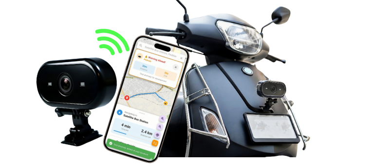
AI-powered dashcam for two-wheelers integrating geospatial analytics and edge AI to detect potholes, map hazards and prevent accidents in real-time.
A Flagship Initiative Under National Geospatial Policy
This startup is associated with the Technology Innovation Hub (TIH) on Positioning and Precision Technologies (PPT) at IIT Tirupati Navavishkar I-Hub Foundation (IITTNiF) through Operation Dronagiri, a flagship initiative of the Department of Science & Technology (DST) Geospatial Data Promotion and Development Committee (GDPDC) and the Geospatial Innovation Cell (GIC) under the National Geospatial Policy (NGP).
Operation Dronagiri demonstrates the power of geospatial technology in transforming Agriculture, Transportation & Infrastructure, and Livelihood & Skilling, aligning with the national vision of Viksit Bharat 2047.
The initiative is powered by the Geo-Intel Lab, the Geospatial Intelligence and Applications Laboratory of IITTNiF, which develops applications and platforms for public good and digital governance. The lab integrates GIS, Remote Sensing, GNSS, and Data Analytics to deliver scalable decision-support systems.
The lab hosts India's first Federated Geospatial Data Interface (GDI) node, enabling seamless data access and collaboration across the national geospatial ecosystem. All products developed under this collaboration are featured on the National Geo-Intel Portal.
"Potential Of Geospatial Technology In Improving Accident Planning And Efficacy Assessment Of Safety Measures"
India witnesses over 1.5 lakh road accidents annually, with two-wheelers accounting for a significant proportion. Current accident planning relies on historical data with limited real-time insights, while safety measure efficacy assessment lacks continuous monitoring capabilities. There is a critical gap in leveraging geospatial intelligence for:
DHAAL addresses this core problem by developing under Operation Dronagiri at IITTNiF to reimagine road safety for two-wheelers. It leverages computer vision and geospatial datasets to detect road hazards and assist riders while creating a dynamic road-quality map for authorities. By combining edge AI with geospatial intelligence, DHAAL transforms every two-wheeler into a mobile sensor, crowdsourcing road safety data for smarter urban planning and continuous safety measure assessment.
Pre-Pilot Integration & Testing Phase
IITTNiF – Geospatial Innovation Accelerator
Vizianagaram, Andhra Pradesh (Planned)
DHAAL detects potholes, obstacles and road anomalies in real time using AI models on embedded hardware. Riders get instant visual and audio alerts, while anonymized hazard data is uploaded for municipal mapping.
The data feeds into a cloud dashboard that helps city officials identify high-risk zones and plan repairs proactively.
Demonstrates geospatial technology's transformative power in Transportation & Infrastructure by creating a crowdsourced, real-time road safety intelligence network aligned with Viksit Bharat 2047's vision for smart cities.
Leverages IITTNiF's Federated GDI for seamless integration of geospatial datasets, enabling data-driven governance and proactive infrastructure maintenance at scale.
Optimized vision models running on connected mobile device for real-time hazard detection with minimal latency.
GSM connectivity along with Wi-Fi sync via companion mobile app for real-time alerts and cloud data upload.
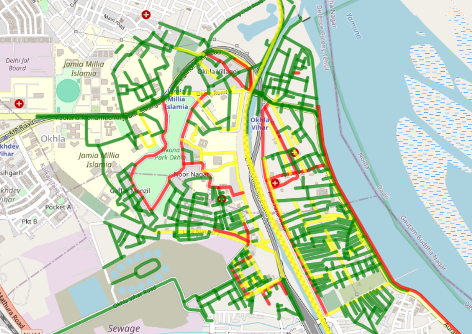
Geo-aggregated hazard visualization via cloud dashboard with OpenStreetMap integration for municipal use.
DHAAL uses GPS/GNSS positioning for accurate hazard location tagging and integrates with OpenStreetMap for road network data. The system is designed to be compatible with geospatial data standards for future integration with government platforms.
Government
DST GDPDC & GIC
Policy support & pilot district coordination
Academia
IIT Tirupati (IITTNiF)
Technical mentorship & GDI access
Corporate (Planned)
Municipal Corporations
Data integration & infrastructure deployment
DHAAL is currently in the pre-pilot phase, working towards deployment in Vizianagaram district. The solution aims to improve rider safety through real-time hazard alerts while collecting road quality data to support municipal infrastructure planning.
Real-time alerts to help riders avoid road hazards and reduce accident risks
Continuous data collection to support municipal planning and maintenance
Crowdsourced data helping identify priority areas for infrastructure improvement
Reducing road accidents and fatalities through preventive technology
Smart infrastructure monitoring and data-driven urban planning
Creating safer, more resilient urban environments through geospatial tech
Our focused approach to building and validating DHAAL's AI-powered road safety technology.
We're currently in the final integration phase, ensuring our technology meets the highest standards before real-world deployment.
The core team driving Operation Dronagiri – DHAAL innovation.

CEO & Co-Founder
Leads product vision, partnerships, and operations strategy for DHAAL. Experienced in building technology solutions for social impact with focus on transportation safety and urban planning.

CTO & Co-Founder
Responsible for system architecture, embedded AI integration, and innovation pipeline. Expert in edge computing, computer vision, and geospatial data systems with focus on real-time applications.
Supported by: IITTNiF Geo-Intel Lab mentors, DST Operation Dronagiri program coordinators, and geospatial technology experts from the National GDI ecosystem.
Interested in collaborating? Reach out to us.